Lynn Amber - Travel & Photography
sharing my thoughts through words and images
Hiking the Eastern Sierras Part I
One of the main goals this summer is to explore on foot some of the hiking trails in and around the greater Eastern Sierra range. My first priority was to get familiar with some trails in close proximity to our campground and around the June Lake Loop. So far, we have hiked two notable trails within the June Lake Loop proper.


RUSH CREEK TRAIL
On one of our first days off after starting work at Oh! Ridge Campground, we decided to tackle a trail just a couple of miles down the road from us. The Rush Creek Trailhead is located just across the road from Silver Lake National Forest Campground – one of several campgrounds that falls under the maintenance duties of Jim’s position. From Hwy 395, take the south junction of Route 158 to a parking lot on the west (left) side of the road. Look for the very visible National Forest signs for this trailhead. I was drawn to this trail for a couple of reasons. A short distance into the hike you enter the Ansel Adams Wilderness Area and I just could not wait to be inside this wilderness area named after one of my favorite photographers! Also, this trail is an access point for some backpackers to the John Muir Trail and the Thousand Island Lake region. I knew we would not make it as far as the John Muir trail but I wanted my first hike in the Eastern Sierras to take me into the wilderness area. The trailhead elevation is 7,250 feet.


We were still getting acclimated to the altitude so we took many breaks on this stretch of the trail to hydrate and enjoy the scenery unfolding around us.
The beginning of the trail winds along the back of the Silver Lake RV Resort through aspen groves and then starts steadily climbing. The views of the June Lake Loop valley from the first leg of the trail were quite spectacular. The trail actually follows the road (although high above) for a while and then climbs with numerous switchbacks. It’s not long before the terrain turns to sagebrush, wildflowers, and the occasional Jeffrey Pine. Mid-day is probably not the best time to be heading out on this hike. It is exposed and hot. But, of course, that’s exactly when we hit the trail!
One interesting feature along this section of the trail is a railway that ascends straight up the hill to Agnew Lake from Silver Lake. The trail crosses this railway several times during the ascent. The tramway was constructed to move supplies to build a series of hydroelectric facilities in the early 1900’s. Dams were built on three natural lakes – Agnew, Gem and Waugh – to enlarge them and use the overflow to generate electricity. The hydroelectric dams still service the towns in the June Lake Loop area. An interesting fact that I read after completing the hike is that this rail system was salvaged from the old gold-mining town of Bodie about 40 miles north on Route 395. Nice to know that materials were recycled back then and put to good use. More on Bodie in another post!

I’ve read that many hikers take a short cut and opt to walk up the staircase-like tramway, but apparently the cable tramway is still used to transport workers and supplies for the hydroelectric dam maintenance. So, taking this detour is not advised as one is never quite sure when a cable car might be encountered!
In early July, the wildflowers are in abundance in the Eastern Sierras and the diversity of plants flowering along the trail was astounding. I was in plant lover’s heaven, and paused numerous times for picture-taking (as well as to catch my breath)! Early in the hike along a shaded section of the trail I discovered a magnificent little plant called Calochortus leichtlinii – Leichtin’s Mariposa Lily.

The delicate, intricate flower literally took my breath away. It is in the Liliaceae family, is a monocot and a perennial herb native to California. According to the USDA Plant Database, the plant communities where this flower typically grows are Yellow Pine, Red Fir and Lodgepine Pine forests as well as subalpine forests. It is commonly found in dry, sandy, rocky areas. One wildflower guide indicates that this species is rarer in the Eastern Sierras, so I felt privileged to have spotted it growing on this trail. Mariposa means *butterfly* in Spanish and the flower petals do indeed resemble butterfly wings. 
Other wildflowers blooming in early July here along the trail include: Castilleja linariifolia – Desert Paintbrush, Eriogonum umbellatum v. nevadense – Nevada Sulfur Flower,

and Penstemon rostriflorus – Bridge’s Penstemon.


I’ve decided to make an informal pact with myself to limit my picture taking to the return leg of our hikes whenever possible otherwise progress is slow. I take note of things I want to photograph and keep my camera handy on the hike out. This only works for an out and back hike however! Hiking poles get in the way too and I tend to put them away when I’m concentrating on photo shoots. I actually lost one of my hiking poles on this hike! I’ve had those poles many years. I collapsed the poles and stuck them in my water bottle pocket thinking this would be secure. Somewhere along the way, one of the poles worked its way out and I did not notice until we were almost down to the trailhead. I figured I was going to need to purchase another set, but as luck would have it, on another hike the next week I found some poles left by a hiker. Funny how that happens!
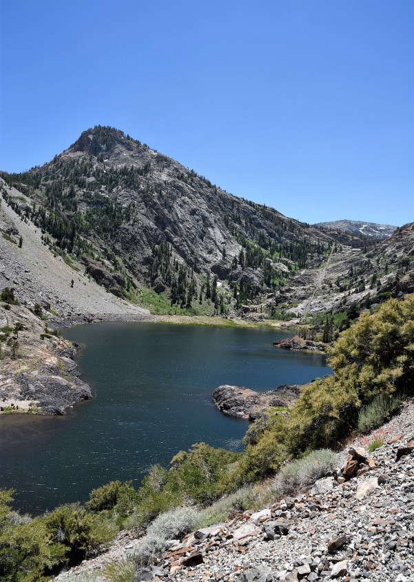
We stopped for lunch at Agnew Lake, one of several lakes that is dammed for hydroelectric power. In the distance, on the other side of the lake, we saw the tramway continuing on steeply to the upper Gem Lake where another dam is visible. We met some women backpackers who had just descended the Clark Lakes trail on the other side of Agnew Lake and were taking a break under some much needed shade trees. They were visibly tired and indicated that this trail was incredibly steep and rugged with some exposure – not for the faint at heart.
After lunch, I continued on ahead of Jim and was more than halfway to Gem Lake when I realized he was not catching up. I backtracked to Agnew Lake, but still no Jim. I came upon some backpackers heading up the trail, gave them a description of my lanky husband and asked if they had seen him. Yes, as a matter of fact, a guy had stopped and talked with them for a while about the weight of their packs and their trip. He had even asked to pick up one pack and put it on to feel the weight. That sounded like Jim! He told them his wife was the better hiker, and kept on hiking up the trail but his legs were feeling it so he had decided to start down.

I caught up with him soon after, and we hiked the rest of the way together. The views heading down the trail into the valley were spectacular.


If you want a good work-out and are reasonably acclimated, then this is a good hike to get in shape. I would definitely extend the trip all the way to Gem Lake since you gain the most elevation on the 2-mile hike to Agnew Lake. It’s only another 1 ½ miles to Gem Lake. If you are interested in an overnight trip, then hiking to the Thousand Island Lake region is a 7-mile hike in, and from what I understand is worth the trek!
PARKER LAKE TRAIL
A couple of weeks later, we wanted a short afternoon hike and decided to take the Parker Lake Trail back to – you guessed it – Parker Lake. This trail is accessed from a parking lot a couple of miles back on the Parker Lake Road. The dirt/gravel forest service access road is located just north of Grant Lake on the June Lake Loop road – Route 158. It is a well-maintained road and should be accessible with most vehicles.

This is a 2-mile hike from the trailhead to Parker Lake with an elevation gain of just 636 feet, making it a very family-friendly hike. The first part of the trail is where you gain most of that elevation. This is a sweet trail with a good diversity of terrain. The first half of the trail traverses through typical sagebrush meadows interspersed with groves of Curl-Leaf Mountain Mahogany – Cercocarpus ledifolius. Along the trail, I could hear the rushing sound of Parker Creek. I quickly realized that we were hiking along the top of a small canyon formed by Parker Creek as it tumbled down the ravine towards Mono Lake.
As we climbed in elevation, the trail flattened out and we found ourselves hiking adjacent to Parker Creek. This section of the creek was slowly ambling through a much different ecosystem. The water was clear and the stones made for a beautiful picture!

We were now in a Jeffrey Pine dominated forest with groves of Aspen trees along the creek. We came upon a large specimen Jeffrey Pine and had to stop for some pictures! I am amazed at how the landscape can change so dramatically from dry sagebrush to moist forest. As we continued our hike and reached Parker Lake, the forest transitioned to Lodgepole Pine.

These two pines are decidedly different and easily identified. Jeffrey Pine (Pinus jeffreyi) is characterized by its cluster of three needles that range in length from 5-10 inches and tends to have an elevation range of 6,000-9,000 feet. The bark on a Jeffrey Pine is deeply grooved, rust-colored with age and has an aromatic smell similar to vanilla. Lodgepole Pine (Pinus contorta) is the only 2-needle per cluster pine in the Sierras and the needles are short in length. The bark of Lodgepole Pine is not furrowed, but is thin and scaly in appearance. These two pines can overlap in elevation range with Lodgepole occurring at much higher elevations up to 11,000 feet. It’s been interesting to become familiar with the habitat of different plants here in the Sierras as it gives me a sense of what vegetation zone I’m in and approximate elevation range.
We reached Parker Lake and were rewarded with a clear blue lake nestled between towering 12,000 foot peaks.
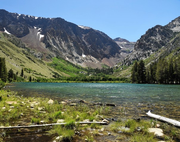
The wind was really buffeting the east side of the lake so we continued on around the lake on an informal side trail to find a sheltered spot to eat lunch.  After lunch, we walked further towards the west side of the lake. There were thickets of shrub willow and moist pockets of grassy areas near the lakeshore that we had to navigate through in search of a trail that continued around the lake

We never found a path through the thicket, but as we were exploring this side of the lake getting lost in the thick cover of shrubs, I stumbled upon a mass of Delphinium glaucum! What a surprise to see this native plant blooming here.

Always on the lookout for plants and wildflowers, I also discovered what I thought was the same Mariposa Lily that I had found on the Rush Creek Trail. I compared the photographs when I got back to the campground, and realized that this was an entirely different species! How thrilling! The species on the Parker Lake trail is Calocortus bruneaunis. The differences in the two species is ever so slight. The Leichtin Mariposa has a white flower with a purplish-brown triangular blotch on the perimeter of a yellow center. The Bruneau Mariposa also has white petals but the center is characterized by a pattern of yellow and burgundy stripes with purple stamens. Side by side, the difference is notable.


Some other plants along the way included :


The advantage to an out and back trail is that the scenery is seen from a different perspective, and therefore, new discoveries make this appear to be new territory. Hiking into the lake, we were focused on what lay ahead, and upon our return, a remarkable view of Mono Lake was revealed to us. We came out of the forest, turned a corner in the hilly sage meadow area and there was Mono Lake off in the distance in all her glory. I love surprises like that.

We decided that at some point in the summer we would hike this trail again, and do it closer to dusk. It seemed like an ideal place to observe wildlife in the early evening visiting the creek and lake.
