Lynn Amber - Travel & Photography
sharing my thoughts through words and images
Eastern Sierras Revisited
We’ve been in Texas almost a month now, and I thought it was time to catch up on showcasing more of our summer adventures.
If you’ve read my previous posts, you have no doubt discovered that the Eastern Sierra region is, at this point in time, one of my favorite places! I’ve written some individual posts about some of the places/hikes that we were particularly fond of – but there is much, much more to add.
So, here goes…..briefly highlighted below are some of the day trips that are most memorable for me, in addition to the detailed posts I’ve already shared. I will cherish these moments in time forever. I’ve tried to be concise with descriptions so I could share more adventures, so more pictures than words!
DEVILS POSTPILE NATIONAL MONUMENT

Since I am a big fan of national parks and associated monuments and historic places, Devils Postpile near Mammoth was high on my list of places to visit. The trip to the monument was one of the first day trips of the summer.
Getting there in mid-summer requires some advanced planning. The road to the national monument is closed to traffic during the summer months for good reason. It is a narrow, winding road that cannot support high traffic volume. During the summer, shuttle buses transport visitors to the monument and back, making a number of stops along the way. There are numerous forest service campgrounds and trailhead access points along the route. This is a popular area for backpacking, and there are many back-country access points for both the Pacific Crest Trail and the John Muir Trail here.
 We chose to drive all the way to Mammoth Mountain Ski Area and hop on the shuttle bus at the Adventure Center. It’s a $7.00 fee for adults and $4.00 fee for children over 2 to ride the bus. And the national parks senior pass (that Jim qualifies for – not me yet!) does not apply unfortunately. I’m not totally on board with this fee, and feel that it could be restrictive for families wanting to access the monument. However, it’s a seasonal shuttle during peak visitation so it is possible to access the monument in the off-season for free when local traffic is allowed on the road.
 Devils Postpile became a national monument in 1911 to protect its unique geologic formation – one of the best examples of columnar basalt in the world. It all began 100,000 years ago, when a lava vent started spewing basaltic lava into the valley where the current day formation exists. Read more about this geologic wonder here. It’s a complicated sequence of events that created the basalt columns we see today, and knowing a bit about the science of the site makes you appreciate the rock outcropping even more.


The national monument also protects the surrounding landscape and Rainbow Falls. We hiked from the ranger station shuttle stop to Rainbow Falls and back, creating a loop and ending up at another shuttle stop for the ride back to Mammoth Mountain. Along the way, we encountered the fire-damaged area caused by the Rainbow Fire, that took place in 1992. Interesting to imagine the devastation and how much the land has rebounded from the fire, with new plant growth.


DUCK PASS TRAIL
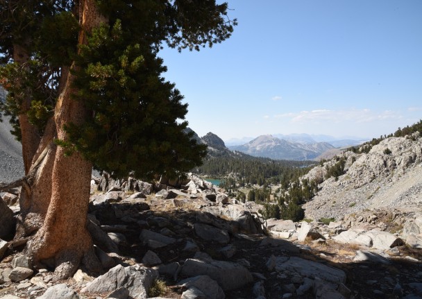
Since Devils Postpile is in the Mammoth area, I decided to stay with the Mammoth theme and share our adventurous hike up to Duke Lake. My niece, Olivia, was in Mammoth over the summer for a weekend visit with her boyfriend’s family and they had chosen this as one of their day hikes. She mentioned that it was an awesome hike, so we made sure to give this trek top priority. The trail head for this hike is located at the Coldwater Campground off Lake Mary Road out of Mammoth. The Duck Pass Trail ascends through the Coldwater Creek watershed, past several lakes and climbs over Duck Pass to Duke Lake.


The hike is about a 7-mile round-trip trek depending on how far you traverse around Duck Lake. Parts of the trail are steep so it’s important to be acclimated before attempting this hike, or your pace will be decidedly slower! There is an elevation gain of about 1800 feet with the elevation at Duck Pass around 9,100 feet. If you hike all the way to the other side of Duck Lake, you would intersect with the Pacific Crest Trail. The scenery was terrific on the exhilarating hike!
Plant life along the way 🙂


Favorite pictures from Duck Pass Trail


HOT CREEK GEOLOGIC SITE

On the outskirts of Mammoth east of Route 395, the Hot Creek Geologic Site sits within the Hot Creek Gorge and is an active geothermal wonder. It is within the Long Valley Caldera which runs from Mono Lake to the start of the Owens River Valley. The hot springs sit atop an ancient volcano and are subject to change with seismic activity, potentially causing sudden changes in water temperature. There are over a dozen steam vents and pools, and if you’re lucky you may even be entertained by rare geyser eruptions.


Along the Hot Creek Fish Hatchery Road are numerous access points to the gorge as it is a popular “catch and release” fly-fishing spot. There is a trail that runs along the south side of the creek. While the hot springs are fenced off, there are still numerous places along the river where you can see small fumaroles and notice water bubbling up from below. If you test the water, you will find it is very HOT at these locations.


The gorge is quite unique, and I recommend taking the time to walk along the creek. I found its beauty to be serene and inspiring. The day we visited there were threats of rain and thunderstorms interspersed with some sun. It made for a dramatic landscape as you can see from some of my photos.


REVERSED PEAK HIKING TRAIL

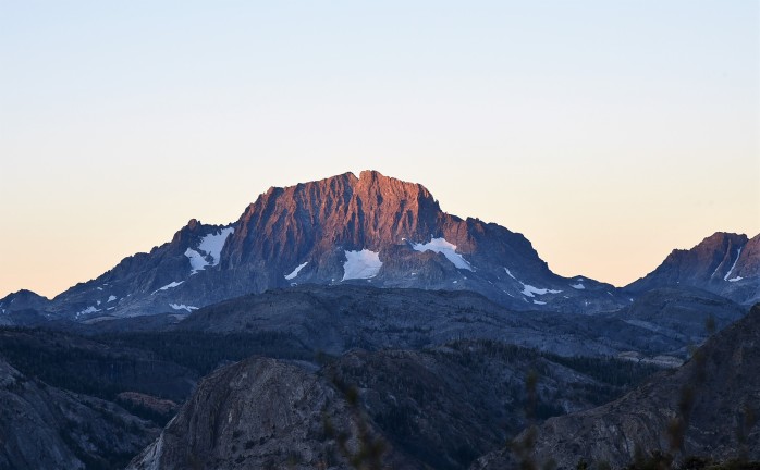
One of the last hikes we did in the Eastern Sierras was right in our backyard. From our campsite, we had a great view of Reversed Peak – the highest point within the inner circle of the June Lake Loop. I read that the summit offers a 360-degree view of the entire loop. I also discovered that the best time to climb the peak is during the pre-dawn hour to take advantage of watching the sunrise across the valley and the loop. It was a hard sell convincing Jim to get up before dawn for the trek up the mountain, but I was relentless and he reluctantly agreed to go. Since we waited until September to do this hike, it was rather chilly when we started off, and windy – but, donned with headlamps, we picked up the pace to get warm and it was not long before we shook off the chill. Jim had not dressed quite warm enough, and I think it was the first time all summer that he out-paced me on a hike!
It’s about a 6-mile round-trip hike and the trailhead is a bit tricky to find. You can access the trail off of the North Shore Dr. in two places, but there are no signs indicating that the trail even exists until you walk back on two forest service roads. Here is a link to a description of the trail and a vague map I found that *sort of* indicates where to find the trail. (The link takes you to the website for the Double Eagle Resort on the June Lake Loop – which by the way has a nice, small bar and Happy Hour every day!) We had hiked the lower loop trail once without taking the side trail to the summit (due to bad storms) and it is a 3.5-mile loop. For the summit hike, we started on the trailhead across from the ballpark – steeper at the onset but a shorter hike to the summit. The trail is steadily uphill and steep in spots with a hard-to-find scramble to the summit. The trail to the top was marked with cairns but they were at times difficult to see.


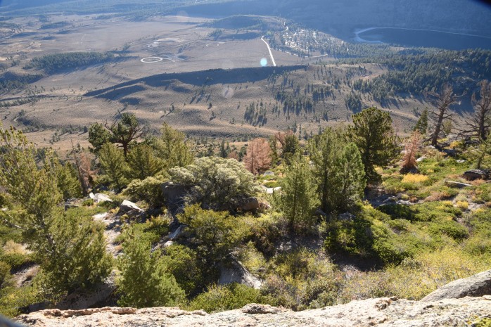
What I liked about the trail was the diversity of terrain. Along the way, the trail passes through an aspen grove, skirts a pine forest and, of course, wanders through the typical sagebrush meadows that I love. The view from the top was awesome! We enjoyed a leisurely cup of coffee while watching the sunrise and it was spectacular. Jim had to admit that it was well worth the pain of such an early morning start time 🙂
The pictures below are heading down the trail after our relaxing visit on Reversed Peak. We were headed for Trout Town Joe’s in June Lake for a hearty breakfast – our motivation to get moving!


hi lynn – nice update. Im pretty sure the tree labeled as a lodgepole is actually a foxtail pine. a really interesting pine as it grows in similar environments as bristlecone pines and lives to be very old, only found in the sierras and grows at high elevations.
WordPress.com | lynnsreversegapyear posted: “We’ve been in Texas almost a month now, and I thought it was time to catch up on showcasing more of our summer adventures.If you’ve read my previous posts, you have no doubt discovered that the Eastern Sierra region is, at this point in time, one of my ” | |
LikeLike
Hi Kate! Thanks for the comment. Good point about the identification of the pine tree above Barney Lake. It certainly could be mistaken for a Foxtail Pine. In my humble opinion, though, I think that it is indeed a Lodgepole – but am open to being proved wrong! 🙂 My reasons for thinking this is a Lodgepole:
1. Foxtail Pines are generally found in a few pockets of the Sierras and surrounding region. The Southern Foxtail Pine – Pinus balfouriana subsp. austrina – is distributed in the Kings Canyon and Sequoia National Parks region, and in the Inyo National Forest area in the White Mountains (near the Bristlecone Pine forest area) The Duck Pass Trail is just southwest of Mammoth Lakes, which is considerably north of Kings Canyon. I’m just not sure that any Foxtail Pine are evident in this area. If so, it is a rare find I think.
2. Your comment got me doing some research – which is always fun for me, and I learned some interesting things about both Lodgepole and Foxtail Pine. For me, I was in part identifying this Lodgepole (Pinus contorta subsp. murrayana) by its bark characteristics – which is mostly what led me to believe this is a Lodgepole Pine, when we first encountered it on the trail. Lodgepole Pine bark is thin, scaly and mottled – described at times as *cornflake* like in appearance. Older bark can take on an orange hue. Foxtail bark is described as thick and platey – deeply furrowed (platy or irregularly deep-fissured or with irregular blocky plates), also with an orange color. The bark on this tree most resembles Lodgepole as I’ve come to observe it.
3. As to habitat, Lodgepole Pine can grow at treeline, and form a *krummholz* habit – being more shrub-like. While Foxtail Pine also grows at treeline, I’ve read that it is almost always single-trunked. Of course, I’m sure that variations exist!
4. Lodgepole Pine overlaps in habitat with both Mountain Hemlock and Whitebark Pine in range and elevation, and we encountered both of these species on this hike as well as numerous Lodgepole Pine. While Lodgepole and Foxtail do inhabit the same areas at times, I think that is mostly in the Sequoia and Kings Canyon areas. But, again, I could be totally wrong.
5. Obviously, one big difference in the species is number of needles per cluster – and I wish I could remember if I verified it was a Lodgepole by examining it for a two-needle configuration. But, alas, I cannot remember – usually I do count needles/cluster. That would of course be a dead give-away!
I would love to know if this is indeed a Lodgepole — if you can show this picture to anyone else with knowledge of the two species, I would be most grateful 🙂
LikeLike
Hey, Lynn! You mention the Pacific Coast Trail, and the Pacific Crest TraiI in this entry. Are there two, or is that a typo? Love, Maria
On Wed, Nov 30, 2016 at 5:52 PM Lynn’s Reverse Gap Year wrote:
> lynnsreversegapyear posted: “We’ve been in Texas almost a month now, and I > thought it was time to catch up on showcasing more of our summer > adventures. If you’ve read my previous posts, you have no doubt discovered > that the Eastern Sierra region is, at this point in time, one of my ” >
LikeLike
Hi Maria!!
No, there are not two! That is most definitely a typo – thanks for catching that. Will edit 🙂
Hope you and family are well !
LikeLike
https://vimeo.com/blog/post/ode-to-desolation-lindsey-hagen-staff-pick-premiere/
I loved this documentary and thought of you and Jim! Ciao! Maris
LikeLike
Finally got a chance to sit and watch this documentary. I’ve heard of these jobs at remote fire watch stations. Something I think Jim and I would enjoy, for sure! Great little film. I loved the quote he mentioned by Barry Lopez describing the lure of the wilderness experience catching us like the snapping of freshly laundered sheets. Thanks for sharing!!
LikeLike