Lynn Amber - Travel & Photography
sharing my thoughts through words and images
Road Trip to Texas: Canyon Tour – Zion – the promised land!

Without consciously planning it this way, our journey to Texas since leaving Sequoia became a study in canyons! While each canyon we visited has its unique character and landscape, these canyons all have one thing in common.
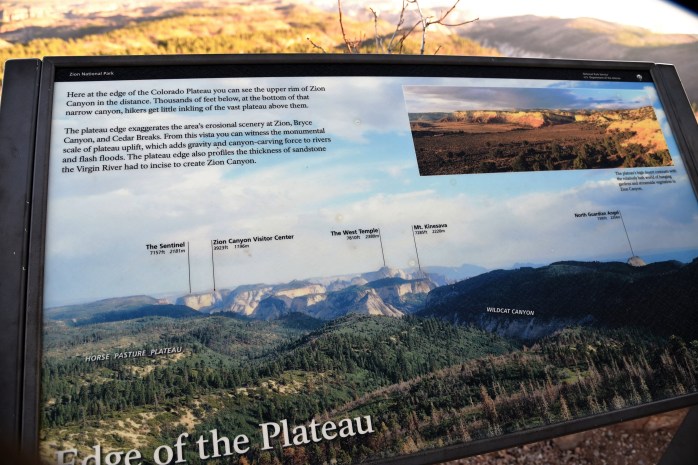
Water was the key force that molded many of the canyons we see today throughout much of the southwest. But, that’s not the whole story. Zion and Bryce Canyons are part of what is described as the Grand Staircase. This is a series of *steps* that traverse the landscape in southwestern Utah starting at Utah’s High Plateau at 9,000 feet and ending with the north rim of the Grand Canyon. These steps are actually numerous bands of colorful cliffs that define each *riser* in the step, and this is what distinguishes Zion and Bryce Canyons. I found a great illustration of this online:

Diagram of the Grand Staircase from Geology of Grand Staircase-Escalante National Monument by Doelling et al
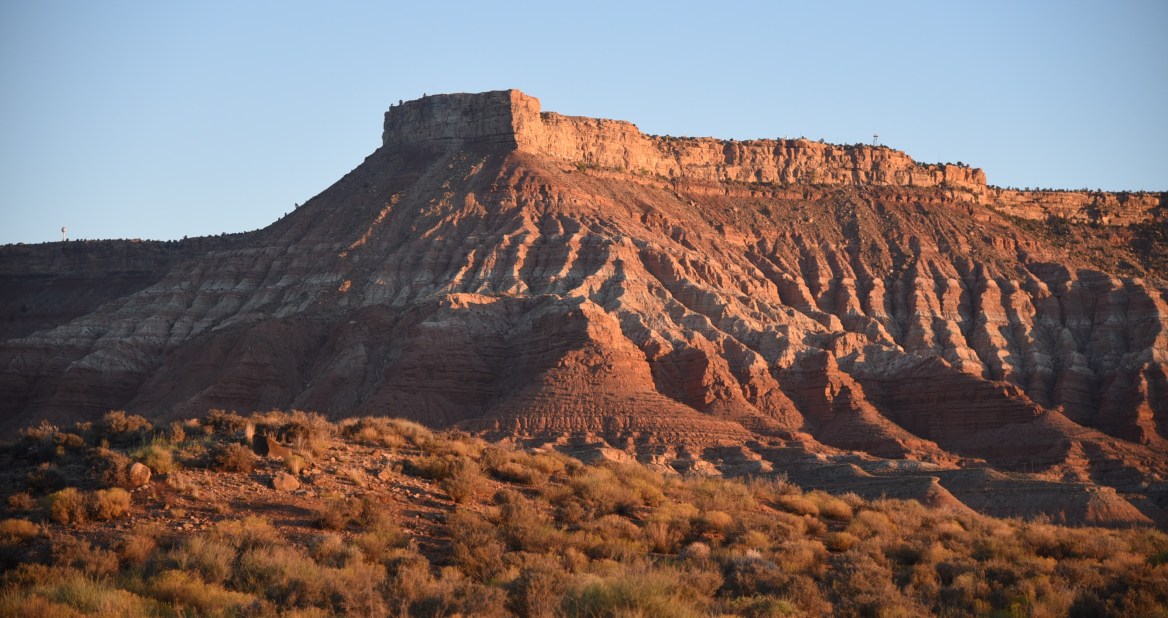
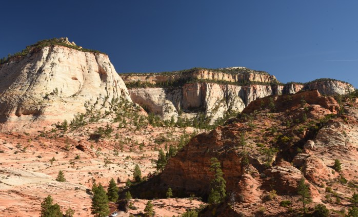
Zion National Park is mostly representative of the Vermillion, Chocolate and White Cliffs of the Grand Staircase while in Bryce Canyon, the Gray and Pink Cliffs persist. Over time, as varying geologic environments and forces occurred in this area (oceans, deserts, earthquakes, and volcanoes), many different layers of sediment, mud and ash were deposited. Pressure and heat caused these layers to turn to stone. The different stratified layers of rock give these canyons a special look and feel. It was interesting to learn that these rock layers formed in such diverse environments as desert sand dunes and sea floors. Some of the rock formations really do resemble giant sand dunes even though they are solid rock! While Zion Canyon was mostly formed by the eroding powers of the Virgin River, apparently the large amphitheaters that comprise Bryce Canyon were formed through the freezing and thawing of water in the cracks of the rocks.
The article linked above (where I grabbed the diagram) gives a very scientific, detailed explanation of the geology of this area of Utah if you are interested in reading more! It’s wicked comprehensive!
ZION IN THREE DAYS!

Our first canyon visit was to Zion National Park located near Springdale, Utah. I have been researching Zion for a while – reading various blogs as well as tapping into Luke’s knowledge of the area. He had recently visited Zion with his girlfriend Sharon in the Spring of 2016 and had some definite suggestions on places we should explore.
Our first major decision, of course, was where to camp. Initially, I had wanted to set up base camp in one of the national park service campgrounds since that would give us easy access to explore with minimal driving. Zion has two RV-friendly campgrounds both of which are located near the South Entrance in Springdale. Watchman Campground allows reservations and I had been checking online for a couple of weeks – there were no open spots for the time we would be in Zion. South Campground is first-come, first-serve only so that was our best hope. I read that you really needed to arrive at the campground early in the morning for any chance at a campsite. The strategy is to be there as soon as the camp hosts know there will be a vacancy, and be in line to grab that site. It was still very crowded in Zion this time of year and like all national parks, they were seeing record numbers of visitors.
We would not make it to Zion until late afternoon, so we needed to come up with an alternative plan for the first night. There happens to be acres and acres of Bureau of Land Management (BLM) property surrounding Zion and several popular boondocking spots in this area have been written about and shared on some blogs that I follow. On BLM land, as well as other federal land, the public is allowed to engage in what is commonly called dispersed camping. You can simply find a spot on federal land, usually off of dirt access roads, and camp for free. Some restrictions do apply and it’s always best to check with local land management offices or district ranger stations if you are not certain about where you can and cannot camp. There have been many blog posting detailing the fine art of boon-docking on federal lands if you desire more information!
I knew about a spot accessed via a dirt road in the small town of Virgin, Utah about 15 miles from the park entrance. We decided to give it a try. The road was a breeze to find with help via Google maps, and we turned onto it and headed off into BLM land. At first, the road seemed in good shape – wide and nicely graded. After crossing a bridge that spans the Virgin River, the road got a tad bumpy and rocky – but still quite passable. When we got to the top of the first hill, there was an ideal spot off to the right on a smaller dirt road that would be perfect for us. It was a large circular dirt patch complete with a stone fire ring. Often times, on federal lands, it is recommended to camp in spots that have been established by other campers in order to lessen the impact to the environment.

There was a sharp rise going from the main dirt road to the side road, and Jim had to put the truck in 4-wheel drive in order to pull the trailer up smoothly. We were able to position the trailer and level it up with very little effort and the view was amazing! We could barely make out the tops of several other RV’s further down the dirt road but no one was camped within a quarter mile of us. We really enjoyed this location. As it turned out, we could not get a spot in the park and ended up just staying here for free for four nights. Zion was only 15 miles down the road and since it was so busy this time of year, it was actually a pleasure to get away from the park in the evening and come back to our secluded and quiet location. Our solitude and 360 degree views of the surrounding cliffs were unrivaled.
I understand that this area is known as Hurricane Cliffs and is a popular mountain-biking destination. While we did not do any biking here on this trip, it is something we’ll definitely explore next time!
Day 1
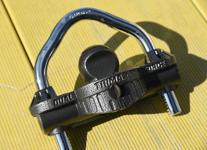
Since this was our first real boon-docking experience, the first full day here we were somewhat hesitant to leave our trailer without some sort of protection from theft. We should have already planned for this, but it just slipped our minds until the time was at hand. So, the first order of business was to venture into the small town of Hurricane, Utah for a hitch lock. Now, you would think that all hitch locks are generally fairly universal. Nope. We found out the hard way this is not so. I’m not going to admit to how many trips back and forth we made from the town of Hurricane to our boon-docking spot – but let’s just say that we had to test and return at least two hitch locks. So, you do the math!
The one we finally found that actually fit our hitch came from an RV supply store. The two that did not work came from an auto parts store. So, what’s the lesson here folks?? We were actually on our way to the RV supply store when we passed an auto parts store – and decided to go there first. Big mistake. Live and learn. The sales lady at the RV Store was great and very knowledgeable. By this time, we were somewhat leery that anything was going to fit our trailer. Airstreams are known for being a tad *unique*. We relayed to her our tragic story about returning hitch locks that did not work. She said that she would pay us $100 if we had to return the one she sold us. She was that confident! Too funny — and she was dead right!
By the time we got the proper hitch lock secured, and ventured into Zion that first day it was late afternoon. The visitor center was just closing, but I was able to get some basic information and we had time for an early evening hike up the Watchman Overlook Trail, which is accessible from the visitor center parking lot.
Watchman Overlook Trail

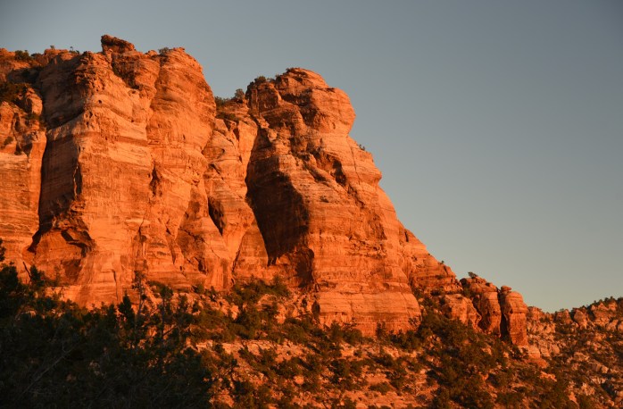
It turned out to be a perfect time for this hike. This is classified as a moderate, 3.3-mile hike that winds its way up to a viewpoint overlooking Watchman, lower Zion Canyon, the visitor center and campgrounds, and Springdale. We could not have timed it better for the opportunity to grab some classic sunset shots of Watchman and the surrounding rock outcroppings. This late in the afternoon, we also managed to miss most of the throngs of people.


Yours truly at the Watchman Overlook – Jim is getting better with the camera!

The landscape aglow with the evening light!
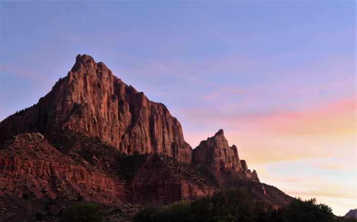
Heading back down the trail, Watchman lit up with the setting sun and the rainbow of colors in the sky was breathtaking!
Day 2
We were on the fence as to what to do the remaining two full days we planned on spending in the park. On the one hand, we wanted to drive the scenic Zion-Mt. Carmel Road (Route 9) through the park and see the eastern side of Zion. We also wanted to do some day hikes in the canyon. We tossed a coin and the road trip through the park won out for the next day.
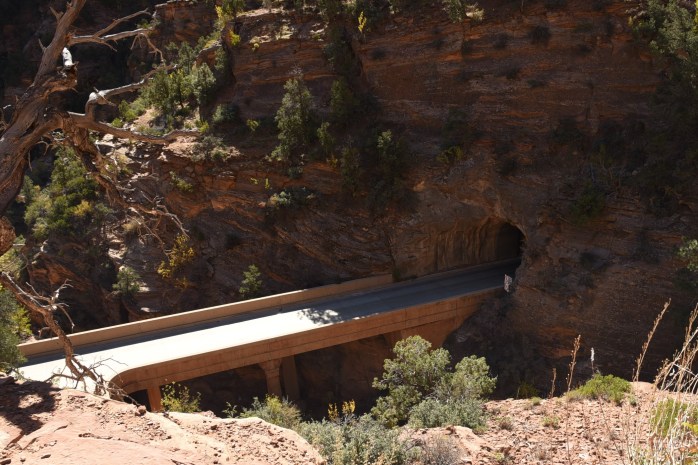
Luke had given us a list of places to stop and explore on our scenic road trip. We managed to capture all of them with time left over to briefly ride the shuttle up Zion Canyon at the end of the day. Our first stop along the Zion-Mt. Carmel Road was the Canyon Overlook Trail. This trail is accessed just past the mile-long tunnel. Wow! What an experience that was going through this tunnel. Mom- don’t think you could have done this or did you??
The Canyon Overlook Trail is a short mile-long trail with some pretty serious drop-offs. Most of the worst drop-offs are protected with a railing but there is some exposure for those who don’t handle heights. So, beware. As it turns out, this is common on most of the trails in the park. So, get used to it if you plan on hiking here!


The trail ends at a viewpoint looking down Pine Canyon towards lower Zion Canyon. It really is quite a sight to behold, and although a short hike, a worthwhile trek. I’ve read that there is a less-marked trail from the viewpoint that takes you around and over some of the rock formations nearby such as East Temple. For the more adventurous, it would be worth researching this. You can find information on the side trail online here.

Our next stop was an unmarked trail that leads to some petroglyphs in the park. We had to rely on information from Luke in order to find this trail. It is apparently not advertised by the park, and rangers will not tell you where to find this trail. We followed Luke’s directions and parked in a small turn-out near the trail access point. To get to the petroglyphs, you have to hike down an embankment from the turn-out, and go through a large stone culvert/tunnel that forms a small bridge on the road. We passed through this culvert and headed down into the canyon. It was not long before we looked to our left and could see the rock wall that contained the petroglyphs.


What a treat! Not very many visitors to Zion are even aware of their existence so I was thrilled to be able to see them up close and personal. Thanks Luke for letting us know they existed and telling us how to find them! They were strikingly similar to the petroglyphs we found in the Eastern Sierras (a post I have yet to write, but coming soon!)
We walked the length of the rock wall twice examining the rock carvings and speculating on their meaning. We found a great spot to eat lunch further back in this canyon and spent some time there just relaxing and enjoying a spot removed from the beaten path.

After lunch, we headed back to our truck and came up on the other side of the road instead of passing through the culvert again. There was a very animated crowd gathered where we had initially walked down to the canyon, and they were enjoying a fantastic view of a herd of Bighorn Sheep! The sheep were gathered in the very spot we had walked less than an hour before. We would have walked right into the middle of the herd had we gone back through the culvert. I perched myself on a rock above the small depression where they were grazing and shot way too many *sheep* photos. I won’t subject you to all of them! I was close enough to reach out and touch some of the sheep as I photographed. Very Cool!


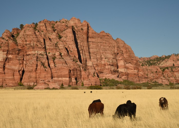
After the sheep moved on, we did too and headed east towards the Checkerboard Mesa. This is an interesting rock formation that really highlights how water and erosion have played a part in creating the marvelous, diverse patterns in the rocks that you see throughout Zion. We stopped off at many turn-outs along the way and just hiked up into small canyons that looked interesting – mostly in pursuit of Keyhole Canyon.
Luke indicted that we had to find and hike up into Keyhole Canyon. Since there was nothing to indicate the name of the canyons along this road, we did not know whether we were finding the right one. At one point, we hiked up this very narrow slot canyon, and found some hikers coming down in the shallow water – complete with wet-suits and climbing gear. They had rappelled down into the canyon and hiked/swam in the slot – a popular activity here in the park. I started talking to one of the gentlemen and asked him if this canyon had a name. He said it was Keyhole Canyon. Success!! We had found the final spot that Luke had mentioned. The guy also shared that it was in this slot canyon where seven hikers were killed the previous year due to a flash flood. I remembered hearing about that, and being in the canyon where it happened was a tad eerie and sad.


After returning to the canyon area on Route 9, we still had plenty of time to take the shuttle up Zion Canyon and hopefully come up with a hiking plan for the next day. We parked at the Canyon Junction shuttle stop and rode the shuttle all the way to the last stop – the Temple of Sinawava. At this stop, we hiked the Riverside Trail to the beginning of the Narrows just to get a look at this famous part of the canyon. Then, we rode back to Canyon Junction while checking out the other potential hiking trails along the way.
Again, our timing was perfect and we were dropped off at Canyon Junction late in the afternoon. The bridge at Canyon Junction is a popular spot for sunset photos, and I could not resist joining the masses in the hopes of getting a good shot! I suppose I should have waited a bit longer for the sun to start setting the rocks on fire, but it was getting brutally crowded on the bridge. Time to go!

Day 3
The next day we woke up early and headed into the park so we could get a jump on the day. I know what you are thinking – totally out of character for us to get an early start, but Zion was more populated than we had anticipated and we needed to get on the trail early! We decided to hike to Upper Emerald Pool, then take the spur trail (Kayenta Trail) over to the West Rim Trail. From there we would hike up the West Rim Trail past the trail that goes to the top of Angel’s Landing. Navigating this network of trails would allow us to cover more territory and experience some of the sights in the canyon. It was a total of about an 8-mile hike, with a very steep 2-mile section from the Grotto to the Angel’s Landing trail.


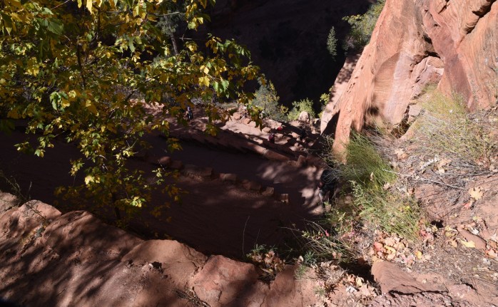
The section of the trail between the Grotto and Angel’s Landing trail was characterized by numerous steep switchbacks, and the famous section called Walter’s Wiggles – a series of 20 very tight and steep twists and turns. We were in great shape by this time of the season, and easily managed the climb. I was surprised to find the trail was paved all of the way to the junction with the Angel’s Landing trail.


We stopped for lunch just past the Angel’s Landing trail. It was a good vantage point to people-watch! There was a steady stream of hikers making their way up the ½ mile trail to the top of Angel’s Landing. It was literally like an expressway during rush hour traffic. No thanks! Angel’s Landing is on the National Register of Historic Landmarks and one of the most popular hikes within the national parks system.


We opted to hike past Scout’s Lookout (at the base of the Angel’s Landing trail) on the West Rim Trail and avoid the crowds.


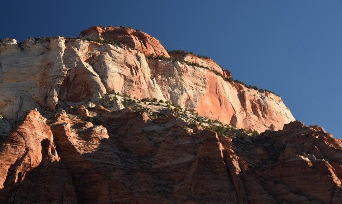
Part of the West Rim Trail past Angel’s Landing

We started hiking back down to the Grotto, and caught the shuttle back to the visitor center later in the afternoon. It was about 3 pm by then, and we decided to leave Zion Canyon and visit a less-traveled section of the park.
In the town near where we were boon-docking, the Kolob Terrace Road travels for about 22 miles north up to Lava Point – located in a remote north-central section of the park. The road traverses in and out of national park property as you wind your way to Lava Point and the scenery was spectacular. The late afternoon light created some interesting opportunities for photographing.

Lava Point is the western terminus for the West Rim Trail we had been hiking earlier in the day. If you can arrange a shuttle, starting at Lava Point on the West Rim Trail and hiking to the Zion Canyon makes for a terrific day hike at about 10 miles for overall distance. It’s also a popular overnight hike.

We arrived back at our campsite towards dusk, and discovered that we had neighbors – very close neighbors. We noticed a motorcycle and a tent set up on the opposite side of our campsite, and we could make out someone hunched over a small backpacker’s stove cooking up something to eat. After parking the truck, we went over to introduce ourselves. The young gentleman interrupted his cooking to shake our hands and told us his name was Frank. A few seconds later, his travel mate, Kate, emerged from the tent. What struck us most about this couple was the condition of the bike they were riding. This was no ordinary bike. It was a 1100 cc BMW and had obviously seen some serious mileage. It was also heavily loaded with gear – appearing to be strapped quite haphazardly around the bike! There was a method to their madness, however. We were curious and asked them where they were headed. This is their amazing story.

Frank and Kate are Czechoslovakian. They started their journey in Czechoslovakia, and are navigating around the world. They crossed Russia and Asia including Mongolia, shipped their bike to North America from South Korea and had traveled at this point from Alaska down to Zion – where we met them. They are recent college graduates – Frank with a mechanical engineering degree and Kate with a degree in Tourism – and are on the final leg of their journey more or less. From Zion, they are heading south and east into Mexico, Central America and ultimately into South America and Argentina before shipping their stuff and themselves back to Europe. I was so impressed with what they were doing. Their genuine interest in meeting other people and seeing other cultures was infectious.

They told us some entertaining stories of their journey through Russia and Mongolia – peppered with tales about the incredibly congenial, helpful people they have met in all places they’ve traveled. Frank is bilingual while Kate speaks several languages including Russian and Spanish. Certainly, that has helped them in their travels. Their expert command of English was notable. They were equally interested in the life style that Jim and I had chosen to live for a while, and just as curious about us. One thing that struck me the most was our mutual faith that humankind – no matter their culture – was inherently good and if everyone could travel and experience first-hand the culture and life style of others, then we would be a more tolerant world community.
Here are some links to their website and social media – I will be anxiously waiting for a book of their travels!


One thing I know for sure – it’s not just the places we are seeing and experiencing that make our RV adventure memorable – but also the unique people like Frank and Kate that we are meeting along the way.

