Lynn Amber - Travel & Photography
sharing my thoughts through words and images
Yosemite: Outside the Valley Part II

We’ve had the opportunity to explore the northern and eastern areas of Yosemite this summer, and have enjoyed some spectacular hikes and sightseeing. I wrote about the Tuolumne Meadows area in an earlier post. The Tioga Pass Road through the northern part of Yosemite is rich with possibilities, and we spent two additional days this summer visiting this area of the park. A couple of the highlights below!!
GAYLOR LAKE TRAIL
Just inside the Tioga Pass east entrance gate is the parking lot and trail access for this hike. Although this has been billed as a less-traveled trail and *hidden gem*, when we arrived at the trailhead the parking was full. (Our usual mid-to-late start to the day did not help!) If you have similar habits as us, then continue on down the road a short distance to a small parking lot on the left side overlooking Dana Meadows. Overflow parking for this trailhead is located here, and we found one of two remaining spots in this lot.
This is a high elevation hike with the trailhead elevation at 9,950. So beware! The first part of the trail up to Gaylor Pass is very steep, and a good test to see if you are acclimated to the altitude! There is roughly a 600-foot gain from the trailhead to the pass in ½ mile of hiking.


The trail ascends through pine forest and is mostly shaded (a welcome relief if hiking in mid-summer) until just before Gaylor Pass, when it opens up to an alpine meadow with outstanding views of the surrounding areas. From the pass, you can see Dana and Gibb Mountains in the distance.
Continuing on the trail, there is a short, switch-back descent to Middle Gaylor Lake and the glacial basin where the other Gaylor Lakes sit nestled in a boulder-strewn valley. This valley is a prime example of the high-country alpine meadow environment and we were blessed to be there when many wildflowers were still in bloom at the end of July.

The trail continues on up to the Sierra Mine and Tioga Hill via the far side of Middle Gaylor Lake, through the meadow, and eventually meanders along and past Upper Gaylor Lake.


From Upper Gaylor Lake, the Sierra Mine ruins become more visible and there is a trail to the top of Tioga Hill where the Great Sierra Mine Historic Site is situated, and the ruins of what was called Dana City. We hiked up past an old miner’s cabin, another ruin that was the old powder house, and past several *adits* – entrances to underground mines. Caution should be used around these mine shafts as they are not cordoned off in any way.


Another hiker we met along the trail told us to continue to the top of the hill past the mine ruins in order to see down the valley and Tioga Lake in the distance. It was well worth the bushwhacking to see this vista!

The Sierra Mine was an old silver mine and the largest mining operation within the boundaries of the Yosemite National Park. It was active between 1881 and 1882. The Great Sierra Consolidated Silver Mining Company purchased all of the claims in this area and established the towns of Dana City and Bennettsville, which was just a bit further east down Tioga Pass. This vein of silver was originally discovered in 1860 by a prospecting party and later named the Sheepherder’s Lode. After just a short time, the Great Sierra Mine on Tioga Hill was deemed unprofitable, due in part to the harsh living conditions and the difficulty with hauling and operating equipment at 11,000 feet. The company shut down this mine, and concentrated efforts at the Bennettsville location. We visited the Bennettsville mine and village location on another trip, mountain-biking the trail into the site.


From the top of Tioga Hill looking west, there is a ridge of rocky terrain that was intriguing to me and I wish we had done some off-trail hiking to explore what was beyond that ridge. It flanked our right side as we made the return trip to Middle Gaylor Lake. I later read that what I was seeing is the edge of a glacial cirque (a bowl-shaped depression formed by glacial erosion) and within the depression are two additional lakes – called the Granite Lakes. I guess I’ll have to put that on the list for next time! While there is no designated trail to these lakes, the terrain here is open and navigation is relatively easy. A good topographical map will keep you on track.


Both the Gaylor Lakes and the Granite Lakes are great fishing destinations for those anglers out there!
As I mentioned earlier, we were here in time to catch a spectacular wildflower show. A great online resource for identifying wildflowers in California is Calflora Plant Search


I would estimate that this is a 4.5-mile roundtrip hike if going all the way up to the Sierra Mine site, with an overall elevation gain of 1,500 feet.
TIOGA PASS ROAD – OLMSTEAD POINT, TENAYA LAKE AND THE MERCED GROVE
Our last trip into Yosemite, we took our bikes and decided to do a *short* bike ride on the Bennettsville trail for a little exercise, and then drive Tioga Road to the western side of Yosemite in search of some giant sequoias.
Technically, the Bennettsville trail is not in Yosemite but it’s close to the east entrance gate. The bike ride was fairly uneventful, some good single-track interspersed with some rough parts of the trail on rocky mine tailings. (This cautious biker walked that part of the trail!) The Bennettsville mining site was rather interesting and two restored buildings still remain where the town was located – the assayer’s office and a barn/bunkhouse.
After the bike ride, we headed to the Merced Grove of sequoias – our final destination for the day. On the way, we stopped off at Tenaya Lake and enjoyed a picnic lunch by the shore.


Unfortunately, we did not have our bathing suits, or I think even I might have taken a dip in the water! And that’s saying something about how appealing it looked, if you know my usual aversion to swimming!

The massive slabs of granite rock and domed mountain tops in this area of Yosemite are quite impressive. All along the Tioga Pass Road is evidence of the glacial action that occurred over hundreds of thousands of years, carving out the landscape and creating these enormous granite slabs and domes.

Past Tenaya Lake, at a significant curve in the road, sits Olmstead Point. From this viewpoint, you look down on Yosemite Valley and Half Dome from a much different perspective. We initially drove on past this overlook without stopping but something made me think twice, and I asked Jim to find a place to turn around.


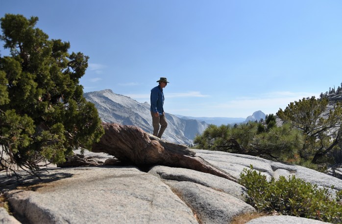
This overlook is named for Frederick Law Olmstead, the father of American landscape architecture, and his son Frederick, Jr. Both were instrumental in helping to initiate the conservation and protection of Yosemite. On the left side of the overlook, Cloud’s Rest rises up in all its glory. This is a massive mountain of granite characterized by an *arête* – a thin, ridge-like summit caused by glacial erosion. The hike to the summit of Cloud’s Rest is a popular destination for park visitors. I can only imagine the exposure this hike provides with the narrow ridge along the summit. Maybe this hike will go on the list for next time! I was so impressed with this viewpoint that we stopped again on our way back over the pass after visiting the Merced Grove! It was close to sunset on the return trip, and this offered some special light for photographs.


MERCED GROVE OF SEQUOIA’S
The Merced Grove of Sequoia’s is the smallest grove in the park and not as heavily travelled – although with the famous Mariposa Grove closed this year, more people are making the trek over to this side of the park -to see this grove. We arrived at the trailhead rather late in the afternoon, but still had plenty of daylight to make the 3-mile roundtrip hike down to the grove.  The first ½ mile of the trail is on a very wide, dirt road. Then, the trail turns to the left and is somewhat narrower and all downhill for a mile to the grove of 20 or so sequoias. These trees are so remarkable. What a contrast to the Eastern Sierra high desert environment we had been exploring most of the summer. Fire has played an important role in maintaining the health of sequoia groves over the years. I learned that the health of the groves suffered when fire suppression was practiced in the area. These trees are also quite susceptible to damage due to soil compaction and erosion by humans. Conservation strategies are employed to reduce the impact – such as the barriers that surround the trees to protect the fragile root system. The Mariposa Grove is closed this year due to a restoration project that is underway to “restore the grove’s dynamic ecology and increase its resilience”. (from www.nps.gov/yose/planyourvisit/mariposagrove.htm)


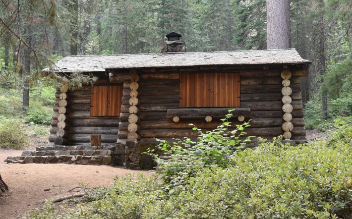
It is a treat to be able to walk among this ancient, giant trees! On the way back to the trailhead from the grove, I was hiking on my own as Jim got side-tracked examining the cabin that was nestled in the woods at the end of the grove of trees. The cabin was built in 1934 to serve as a summer retreat for park superintendents. It now serves as a periodic educational center for school groups. While Jim studied the architecture of the building, I was starting to get eaten alive with mosquitos! Time to go! On my solitary hike back to the parking lot, I was struck by the complete quiet of the forest. There were few hikers on the trail at this point in the day. What a glorious private trek alone in the woods with only my thoughts to keep me company! It was refreshing. To quote John Muir once again, “In every walk with nature one receives far more than he seeks.”